Geolocate

Takukot topographic map

Click on the map to display elevation.

About this map

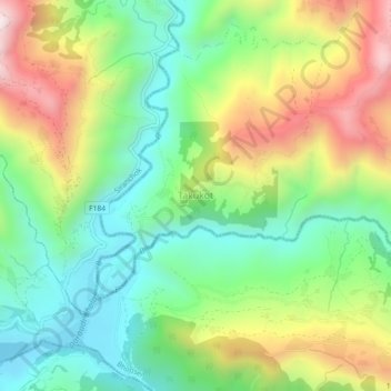
Name: Takukot topographic map, elevation, terrain.

Location: Takukot, Sulikot, Gorkha, Gandaki Province, 34000, Nepal (28.04462 84.64232 28.08462 84.68232)

Average elevation: 776 m

Minimum elevation: 470 m

Maximum elevation: 1,271 m

Other topographic maps

Click on a map to view its topography, its elevation and its terrain.

Gorkha

Nepal > Gandaki Province > Gorkha

Average elevation: 787 m

Chum Nubri

Nepal > Gandaki Province > Gorkha

Average elevation: 4,445 m

Chum Nubri

Nepal > Gandaki Province > Gorkha

Average elevation: 4,445 m

Gear up for your next adventure:

🧼Biodegradable Camp Soap - Environmentally friendly cleaning for gear and body
🚲MTB Frame Bag - Carry tools and maps directly on your bicycle frame
Camping Tent - Weather-resistant tents suitable for 2 to 6 people
🔨Vehicle Emergency Tool - Safety tool for remote road trips to trailheads
🧥Waterproof Pants - Keep dry during rainy hiking conditions

As an Amazon Associate, this site earns from qualifying purchases at no extra cost to you.