
Thank you for supporting this site ❤️
Make a donation
Make a donation
Gear up for your next adventure:
As an Amazon Associate, this site earns from qualifying purchases at no extra cost to you.
Wardhausen topographic map
Click on the map to display elevation.
Thank you for supporting this site ❤️
Make a donation
Make a donation
Gear up for your next adventure:
As an Amazon Associate, this site earns from qualifying purchases at no extra cost to you.
About this map
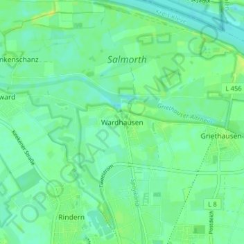
Name: Wardhausen topographic map, elevation, terrain.
Average elevation: 15 m
Minimum elevation: 8 m
Maximum elevation: 24 m
Thank you for supporting this site ❤️
Make a donation
Make a donation
Gear up for your next adventure:
As an Amazon Associate, this site earns from qualifying purchases at no extra cost to you.
Other topographic maps
Click on a map to view its topography, its elevation and its terrain.
Kleve
Deutschland > Nordrhein-Westfalen > Kreis Kleve > Kleve
Kleve gehört geografisch zur Unteren Rheinniederung und zu den Niederrheinischen Höhen, beides Teile des Niederrheinischen Tieflands.
Average elevation: 39 m