
William O. Douglas Wilderness topographic map
Interactive map
Click on the map to display elevation.
William O. Douglas Wilderness
While significant portions of the William O. Douglas Wilderness are high elevation forest, the overall topography is varied. The tallest and most visually striking peak is Mount Aix at 7,766 feet (2,367 m) with a prominence of 3,286 feet (1,002 m). The Cougar Lakes portion is characterized by high alpine lakes, and the Tumac Plateau is dotted with numerous lakes in a forest setting. The eastern edges of this wilderness drop to mid-elevation pine forest and bare ridges. The Meeks Table Natural Research Area, located on a basalt table mountain, is within the wilderness at its eastern boundary.
About this map
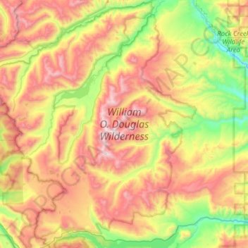
Name: William O. Douglas Wilderness topographic map, elevation, terrain.
Average elevation: 1,371 m
Minimum elevation: 670 m
Maximum elevation: 2,325 m