
Make a donation
Gear up for your next adventure:
As an Amazon Associate, this site earns from qualifying purchases at no extra cost to you.
Agüero topographic map
Click on the map to display elevation.
Make a donation
Gear up for your next adventure:
As an Amazon Associate, this site earns from qualifying purchases at no extra cost to you.
About this map
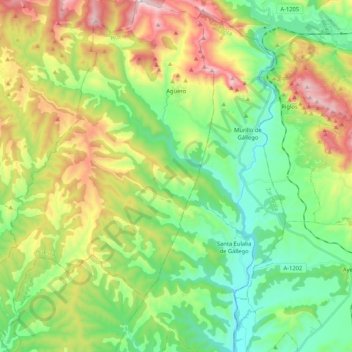
Name: Agüero topographic map, elevation, terrain.
Average elevation: 699 m
Minimum elevation: 421 m
Maximum elevation: 1,213 m
Make a donation
Gear up for your next adventure:
As an Amazon Associate, this site earns from qualifying purchases at no extra cost to you.
Other topographic maps
Click on a map to view its topography, its elevation and its terrain.
Bastarás
Spanje > Aragón > Hoya de Huesca / Plana de Uesca > Casbas de Huesca/Casbas de Uesca
Average elevation: 729 m
Vall de Montó
Spanje > Aragón > Hoya de Huesca / Plana de Uesca > Alcalá del Obispo/Alcalá d’o Bispe
Average elevation: 506 m
Riglos
Spanje > Aragón > Hoya de Huesca / Plana de Uesca > Las Peñas de Riglos
Average elevation: 726 m