
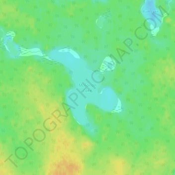
McFarlan Lake topographic map
Interactive map
Click on the map to display elevation.
About this map
Name: McFarlan Lake topographic map, elevation, terrain.
Average elevation: 283 m
Minimum elevation: 269 m
Maximum elevation: 298 m
Other topographic maps
Click on a map to view its topography, its elevation and its terrain.
Esnagi Lake
Canada > Ontario > Unorganized North Algoma
Esnagi Lake, Unorganized North Algoma, Algoma District, Northeastern Ontario, Ontario, Canada
Average elevation: 391 m
White River
Canada > Ontario > Unorganized North Algoma
White River, Unorganized North Algoma, Algoma District, Ontario, B3H 0A6, Canada
Average elevation: 413 m
Achigan Lake
Canada > Ontario > Unorganized North Algoma
Achigan Lake, Unorganized North Algoma, Algoma District, Northeastern Ontario, Ontario, Canada
Average elevation: 377 m
Kapuskasing Lake
Canada > Ontario > Unorganized North Algoma
Kapuskasing Lake, Unorganized North Algoma, Algoma District, Ontario, Canada
Average elevation: 328 m
Goulais River
Canada > Ontario > Unorganized North Algoma
Goulais River, Unorganized North Algoma, Algoma District, Northeastern Ontario, Ontario, Canada
Average elevation: 472 m
Parisien Lake
Canada > Ontario > Unorganized North Algoma
Parisien Lake, Highway 553, Unorganized North Algoma, Algoma District, Northeastern Ontario, Ontario, Canada
Average elevation: 360 m
Lower Island Lake
Canada > Ontario > Unorganized North Algoma
Lower Island Lake, Unorganized North Algoma, Algoma District, Northeastern Ontario, Ontario, Canada
Average elevation: 346 m
Peterbell
Canada > Ontario > Unorganized North Algoma
Peterbell, Unorganized North Algoma, Algoma District, Northeastern Ontario, Ontario, Canada
Average elevation: 309 m
Beaverhouse Lake
Canada > Ontario > Unorganized North Algoma
Beaverhouse Lake, Unorganized North Algoma, Algoma District, Northeastern Ontario, Ontario, Canada
Average elevation: 428 m
Ranger Lake
Canada > Ontario > Unorganized North Algoma
Ranger Lake, Unorganized North Algoma, Algoma District, Ontario, Canada
Average elevation: 464 m
Pancake Bay Provincial Park
Canada > Ontario > Unorganized North Algoma
Pancake Bay Provincial Park, Unorganized North Algoma, Algoma District, Northeastern Ontario, Ontario, Canada
Average elevation: 190 m
Michipicoten River
Canada > Ontario > Unorganized North Algoma
Michipicoten River, Unorganized North Algoma, Algoma District, Ontario, Canada
Average elevation: 316 m
Alces Lake
Canada > Ontario > Unorganized North Algoma
Alces Lake, Unorganized North Algoma, Algoma District, Northeastern Ontario, Ontario, Canada
Average elevation: 463 m
Batchawana River
Canada > Ontario > Unorganized North Algoma
Batchawana River, Unorganized North Algoma, Algoma District, Northeastern Ontario, Ontario, Canada
Average elevation: 428 m
Orphan Lake
Canada > Ontario > Unorganized North Algoma
Orphan Lake, Unorganized North Algoma, Algoma District, Northeastern Ontario, Ontario, Canada
Average elevation: 235 m
Missinaibi River
Canada > Ontario > Unorganized North Algoma
Missinaibi River, Unorganized North Algoma, Algoma District, Ontario, Canada
Average elevation: 380 m
Magpie River
Canada > Ontario > Unorganized North Algoma
Magpie River, Unorganized North Algoma, Algoma District, Ontario, Canada
Average elevation: 420 m
Manitou Mountain
Canada > Ontario > Unorganized North Algoma
Manitou Mountain, Unorganized North Algoma, Algoma District, Northeastern Ontario, Ontario, Canada
Average elevation: 378 m
Alex Lake
Canada > Ontario > Unorganized North Algoma
Alex Lake, Unorganized North Algoma, Algoma District, Northeastern Ontario, Ontario, Canada
Average elevation: 296 m
Berry Lake
Canada > Ontario > Unorganized North Algoma
Berry Lake, Unorganized North Algoma, Algoma District, Northeastern Ontario, Ontario, Canada
Average elevation: 456 m
Anjigami Lake
Canada > Ontario > Unorganized North Algoma
Anjigami Lake, Unorganized North Algoma, Algoma District, Ontario, Canada
Average elevation: 344 m
Big Horseshoe Lake
Canada > Ontario > Unorganized North Algoma
Big Horseshoe Lake, Unorganized North Algoma, Algoma District, Ontario, Canada
Average elevation: 440 m
Goat River
Canada > Ontario > Unorganized North Algoma
Goat River, Unorganized North Algoma, Algoma District, Northeastern Ontario, Ontario, Canada
Average elevation: 355 m
Seymour Lake
Canada > Ontario > Unorganized North Algoma
Seymour Lake, Unorganized North Algoma, Algoma District, Northeastern Ontario, Ontario, Canada
Average elevation: 433 m
Fire River
Canada > Ontario > Unorganized North Algoma
Fire River, Unorganized North Algoma, Algoma District, Northeastern Ontario, Ontario, Canada
Average elevation: 401 m
Oboe Lake
Canada > Ontario > Unorganized North Algoma
Oboe Lake, Unorganized North Algoma, Algoma District, Ontario, Canada
Average elevation: 476 m
Pukaskwa River
Canada > Ontario > Unorganized North Algoma
Pukaskwa River, Unorganized North Algoma, Algoma District, Ontario, Canada
Average elevation: 482 m
Puzzle Lake
Canada > Ontario > Unorganized North Algoma
Puzzle Lake, Buck Lake Road, Unorganized North Algoma, Algoma District, Ontario, Canada
Average elevation: 298 m
Goat River
Canada > Ontario > Unorganized North Algoma
Goat River, Unorganized North Algoma, Algoma District, Ontario, Canada
Average elevation: 321 m
Jackpine River
Canada > Ontario > Unorganized North Algoma
Jackpine River, Unorganized North Algoma, Algoma District, Ontario, Canada
Average elevation: 374 m
Opasatika Lake
Canada > Ontario > Unorganized North Algoma
Opasatika Lake, Unorganized North Algoma, Algoma District, Ontario, Canada
Average elevation: 265 m
Harmony River
Canada > Ontario > Unorganized North Algoma
Harmony River, Unorganized North Algoma, Algoma District, Ontario, Canada
Average elevation: 346 m
Wejinabikun Lake
Canada > Ontario > Unorganized North Algoma
Wejinabikun Lake, Road 401, Unorganized North Algoma, Algoma District, Ontario, Canada
Average elevation: 379 m
Oba Lake
Canada > Ontario > Unorganized North Algoma
Oba Lake, Road 603, Unorganized North Algoma, Algoma District, Ontario, Canada
Average elevation: 370 m
Wigwam River
Canada > Ontario > Unorganized North Algoma
Wigwam River, Unorganized North Algoma, Algoma District, Ontario, Canada
Average elevation: 313 m
Mamainse Harbour
Canada > Ontario > Unorganized North Algoma
Mamainse Harbour, Highway 17, Unorganized North Algoma, Algoma District, Ontario, Canada
Average elevation: 192 m