
Make a donation
Gear up for your next adventure:
As an Amazon Associate, this site earns from qualifying purchases at no extra cost to you.
Pals topographic map
Click on the map to display elevation.
Make a donation
Gear up for your next adventure:
As an Amazon Associate, this site earns from qualifying purchases at no extra cost to you.
About this map
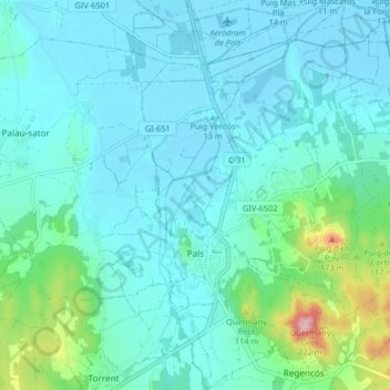
Name: Pals topographic map, elevation, terrain.
Location: Pals, Bas-Ampurdan, Gérone, Catalogne, 17256, Espagne (41.94975 3.13471 42.01050 3.20749)
Average elevation: 33 m
Minimum elevation: -3 m
Maximum elevation: 212 m
Make a donation
Gear up for your next adventure:
As an Amazon Associate, this site earns from qualifying purchases at no extra cost to you.
Other topographic maps
Click on a map to view its topography, its elevation and its terrain.
Platja d'Aro
Espagne > Catalogne > Bas-Ampurdan > Castell d'Aro, Platja d'Aro i s'Agaró
Average elevation: 47 m
Castell d'Aro
Espagne > Catalogne > Bas-Ampurdan > Castell d'Aro, Platja d'Aro i s'Agaró
Average elevation: 94 m
Make a donation
Gear up for your next adventure:
As an Amazon Associate, this site earns from qualifying purchases at no extra cost to you.
Make a donation
Gear up for your next adventure:
As an Amazon Associate, this site earns from qualifying purchases at no extra cost to you.