
Hameau des Ouitres topographic map
Interactive map
Click on the map to display elevation.
About this map
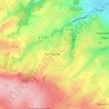
Name: Hameau des Ouitres topographic map, elevation, terrain.
Average elevation: 96 m
Minimum elevation: 2 m
Maximum elevation: 180 m
Other topographic maps
Click on a map to view its topography, its elevation and its terrain.
Carrefour du Mautalon
France > Normandie > Manche > La Hague > Tonneville
Carrefour du Mautalon, Tonneville, La Hague, Cherbourg, Manche, Normandie, France métropolitaine, 50460, France
Average elevation: 109 m