
Thank you for supporting this site ❤️
Make a donation
Make a donation
Gear up for your next adventure:
As an Amazon Associate, this site earns from qualifying purchases at no extra cost to you.
Sonnberg topographic map
Click on the map to display elevation.
Thank you for supporting this site ❤️
Make a donation
Make a donation
Gear up for your next adventure:
As an Amazon Associate, this site earns from qualifying purchases at no extra cost to you.
About this map
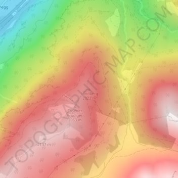
Name: Sonnberg topographic map, elevation, terrain.
Location: Sonnberg, Tösens, Bezirk Landeck, Tirol, 6541, Österreich (46.98956 10.60811 46.98966 10.60821)
Average elevation: 1,699 m
Minimum elevation: 930 m
Maximum elevation: 2,192 m
Thank you for supporting this site ❤️
Make a donation
Make a donation
Gear up for your next adventure:
As an Amazon Associate, this site earns from qualifying purchases at no extra cost to you.