Geolocate

Manantial topographic map

Click on the map to display elevation.

About this map

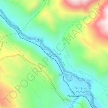
Name: Manantial topographic map, elevation, terrain.

Location: Manantial, Curicaca, Jauja, Junín, Perú (-11.77502 -75.74203 -11.73502 -75.70203)

Average elevation: 3,797 m

Minimum elevation: 3,512 m

Maximum elevation: 4,342 m

Gear up for your next adventure:

🧦Thermal Socks - Warm socks for winter hiking or camping
🧭GPS Handheld Device - Reliable GPS navigation for outdoor adventures
Bushcraft Tarp - Versatile emergency shelter or gear protection
🧢Sun Hat - Wide-brim hat for sun protection
💧Reusable Water Bottle - Durable water bottles for hydration on trails

As an Amazon Associate, this site earns from qualifying purchases at no extra cost to you.