Geolocate

Wolvega topographic map

Click on the map to display elevation.

About this map

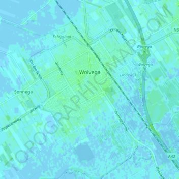
Name: Wolvega topographic map, elevation, terrain.

Location: Wolvega, Weststellingwerf, Frisia, Netherlands (52.84897 5.97107 52.89452 6.04366)

Average elevation: 2 m

Minimum elevation: -3 m

Maximum elevation: 7 m

Other topographic maps

Click on a map to view its topography, its elevation and its terrain.

Vierhuizen

Netherlands > Frisia > Allingawier

Average elevation: -2 m

Oost-Vlieland

Netherlands > Frisia

Average elevation: 2 m

Kooiplaats

Netherlands > Frisia > Buren

Average elevation: 1 m

Loënga

Netherlands > Frisia > Loënga

Average elevation: 0 m

Leeuwarden

Netherlands > Frisia > Leeuwarden

Average elevation: 0 m

Gear up for your next adventure:

🧣Merino Neck Gaiter - Protects against wind, sun, and cold at high altitudes
🩹Compact First Aid Kit - Pre-packed essentials for common trail injuries
🥾Trekking Poles - Adjustable trekking poles to reduce knee stress and improve stability
🧦Crew Hiking Socks - Comfortable socks for long-distance hikes
🥾Mountain Hiking Shoes - Shoes with superior grip for mountainous terrain

As an Amazon Associate, this site earns from qualifying purchases at no extra cost to you.