Geolocate

Yawkey topographic map

Click on the map to display elevation.

About this map

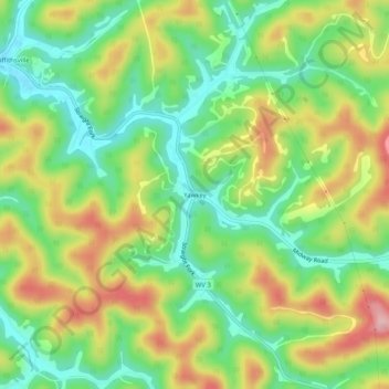
Name: Yawkey topographic map, elevation, terrain.

Location: Yawkey, Lincoln County, West Virginia, 25573, United States (38.20482 -81.98518 38.24482 -81.94518)

Average elevation: 274 m

Minimum elevation: 198 m

Maximum elevation: 379 m

Other topographic maps

Click on a map to view its topography, its elevation and its terrain.

Hamlin

United States > West Virginia > Lincoln County

Average elevation: 241 m

Gear up for your next adventure:

🧭Orienteering Kit - Tools for map reading and navigation in the wild
🧶550 Survival Paracord - Versatile utility cord for emergency repairs and rigging
🧢Beanie Hat - Keep your head warm in cold weather
🔦LED Headlamp - Hands-free lighting for early morning starts or late finishes
🥾Trekking Boots - Durable boots for long-distance trekking

As an Amazon Associate, this site earns from qualifying purchases at no extra cost to you.