
Make a donation
Gear up for your next adventure:
As an Amazon Associate, this site earns from qualifying purchases at no extra cost to you.
Rubonia topographic map
Click on the map to display elevation.
Make a donation
Gear up for your next adventure:
As an Amazon Associate, this site earns from qualifying purchases at no extra cost to you.
About this map
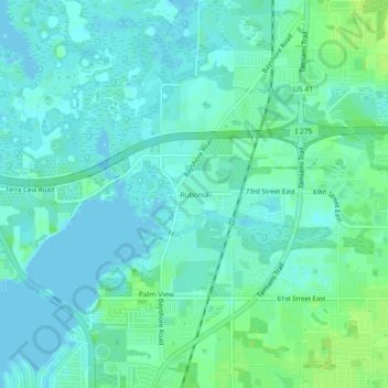
Name: Rubonia topographic map, elevation, terrain.
Location: Rubonia, Manatee County, Florida, 34221, United States (27.55892 -82.57260 27.59892 -82.53260)
Average elevation: 5 m
Minimum elevation: -2 m
Maximum elevation: 13 m
Make a donation
Gear up for your next adventure:
As an Amazon Associate, this site earns from qualifying purchases at no extra cost to you.
Other topographic maps
Click on a map to view its topography, its elevation and its terrain.
Make a donation
Gear up for your next adventure:
As an Amazon Associate, this site earns from qualifying purchases at no extra cost to you.
Anna Maria Bayfront Park
United States > Florida > Manatee County > Anna Maria island
Average elevation: 1 m
Make a donation
Gear up for your next adventure:
As an Amazon Associate, this site earns from qualifying purchases at no extra cost to you.
Summerfield Community Park
United States > Florida > Manatee County > Bradenton
Average elevation: 10 m