Geolocate

Sineu topographic map

Click on the map to display elevation.

About this map

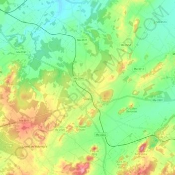
Name: Sineu topographic map, elevation, terrain.

Location: Sineu, Pla de Mallorca, Balearic Islands, 07510, Spain (39.60882 2.96483 39.68945 3.08556)

Average elevation: 113 m

Minimum elevation: 40 m

Maximum elevation: 239 m

Other topographic maps

Click on a map to view its topography, its elevation and its terrain.

Sa Figuera

Spain > Balearic Islands > Pla de Mallorca > Montuïri

Average elevation: 159 m

Ruberts

Spain > Balearic Islands > Pla de Mallorca > Sencelles

Average elevation: 124 m

Judí

Spain > Balearic Islands > Pla de Mallorca > Sencelles > Ruberts

Average elevation: 108 m

Son Cortana

Spain > Balearic Islands > Pla de Mallorca > Algaida

Average elevation: 185 m

Gear up for your next adventure:

🥾Trail Hiking Boots - Supportive boots for rough trails
🧴Outdoor Sunscreen - High SPF protection for high-altitude UV exposure
🧥Thermal Fleece Jacket - Versatile insulation for changing mountain temperatures
🧼Travel Hand Sanitizer - Keep hands clean when water is scarce
🧥Packable Rain Jacket - Breathable waterproof layer for unpredictable weather

As an Amazon Associate, this site earns from qualifying purchases at no extra cost to you.