Geolocate

Steinach topographic map

Click on the map to display elevation.

About this map

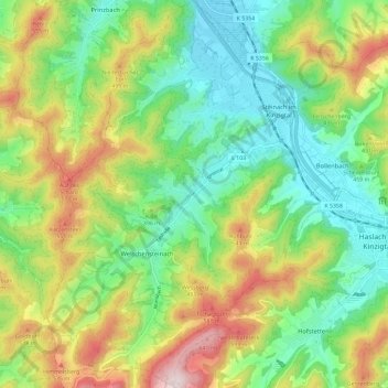
Name: Steinach topographic map, elevation, terrain.

Location: Steinach, Verwaltungsgemeinschaft Haslach im Kinzigtal, Ortenaukreis, Baden-Württemberg, 77790, Germany (48.24755 7.98754 48.32513 8.07615)

Average elevation: 370 m

Minimum elevation: 192 m

Maximum elevation: 679 m

Other topographic maps

Click on a map to view its topography, its elevation and its terrain.

Schliffkopf

Germany > Baden-Württemberg > Ortenaukreis > Oppenau

Average elevation: 864 m

Waldulm

Germany > Baden-Württemberg > Ortenaukreis

Average elevation: 287 m

Hilsenhof

Germany > Baden-Württemberg > Ortenaukreis > Seebach

Average elevation: 529 m

Einach

Germany > Baden-Württemberg > Ortenaukreis > Gengenbach > Einach

Average elevation: 256 m

Gear up for your next adventure:

🧴Sunscreen SPF - Broad-spectrum sunscreen for outdoor activities
🚑Survival Whistle - Signal for help across long distances in mountains
🚲Handlebar Phone Mount - View topographic-map.com live while cycling
📷Outdoor Action Camera - Capture high-elevation views and rugged adventures
🦶Anti-Blister Balm - Prevents friction and hotspots during long ascents

As an Amazon Associate, this site earns from qualifying purchases at no extra cost to you.