Geolocate

Cacra topographic map

Click on the map to display elevation.

About this map

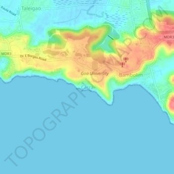
Name: Cacra topographic map, elevation, terrain.

Location: Cacra, Tiswadi, North Goa, Goa, 403206, India (15.43207 73.81598 15.47207 73.85598)

Average elevation: 15 m

Minimum elevation: -2 m

Maximum elevation: 70 m

Other topographic maps

Click on a map to view its topography, its elevation and its terrain.

Divar Island

India > Goa > Tiswadi > Naroa

Average elevation: 11 m

Miramar Beach

India > Goa > Tiswadi > Panaji

Average elevation: 3 m

Mala Lake

India > Goa > Tiswadi > Panaji

Average elevation: 10 m

Divar Island

India > Goa > Tiswadi > Piedade

Average elevation: 11 m

Chorão Island

India > Goa > Tiswadi > Chorao

Average elevation: 13 m

Gear up for your next adventure:

🪑Ultralight Camping Stool - Compact seating for rest stops during long hikes
🔦UV Flashlight - Detect minerals or specific insects in the dark
Lightweight Camping Tent - Portable shelter optimized for Canadian backcountry camping
🛰️Satellite Messenger - Emergency communication for areas with no cell service
🚲Heavy Duty Bike Lock - Secure your bike at the trailhead or during stops

As an Amazon Associate, this site earns from qualifying purchases at no extra cost to you.