
Make a donation
Gear up for your next adventure:
As an Amazon Associate, this site earns from qualifying purchases at no extra cost to you.
Camden topographic map
Click on the map to display elevation.
Make a donation
Gear up for your next adventure:
As an Amazon Associate, this site earns from qualifying purchases at no extra cost to you.
About this map
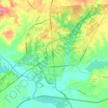
Name: Camden topographic map, elevation, terrain.
Location: Camden, Kershaw County, South Carolina, United States (34.21628 -80.65768 34.30000 -80.53743)
Average elevation: 68 m
Minimum elevation: 35 m
Maximum elevation: 123 m
Make a donation
Gear up for your next adventure:
As an Amazon Associate, this site earns from qualifying purchases at no extra cost to you.
Other topographic maps
Click on a map to view its topography, its elevation and its terrain.
Battle of Camden National Historic Landmark
United States > South Carolina > Kershaw County > Flat Rock
Average elevation: 104 m
Make a donation
Gear up for your next adventure:
As an Amazon Associate, this site earns from qualifying purchases at no extra cost to you.
Make a donation
Gear up for your next adventure:
As an Amazon Associate, this site earns from qualifying purchases at no extra cost to you.
Sunnyhill
United States > South Carolina > Kershaw County > Camden > Sunnyhill
Average elevation: 86 m