Geolocate

Swainsboro topographic map

Click on the map to display elevation.

About this map

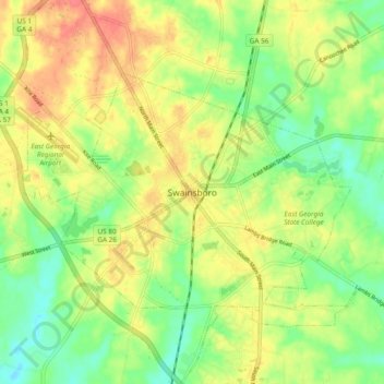
Name: Swainsboro topographic map, elevation, terrain.

Location: Swainsboro, Emanuel County, Georgia, 30401, United States (32.55739 -82.37374 32.63739 -82.29374)

Average elevation: 88 m

Minimum elevation: 62 m

Maximum elevation: 115 m

Gear up for your next adventure:

🛏️Camping Sleeping Mat - Comfortable mats for sleeping outdoors
🔋Lithium AA Batteries - Long-lasting power that performs in extreme cold
Tent Footprint - Protect tent floor and increase durability
🥾Hiking Leggings - Comfortable leggings for outdoor activities
🧭GPS Tracker - Track your location in remote areas safely

As an Amazon Associate, this site earns from qualifying purchases at no extra cost to you.