Geolocate

Monticello topographic map

Click on the map to display elevation.

About this map

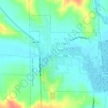
Name: Monticello topographic map, elevation, terrain.

Location: Monticello, Green County, Wisconsin, United States (42.73676 -89.60288 42.75622 -89.57751)

Average elevation: 266 m

Minimum elevation: 251 m

Maximum elevation: 309 m

Other topographic maps

Click on a map to view its topography, its elevation and its terrain.

Juda

United States > Wisconsin > Green County

Average elevation: 275 m

Attica

United States > Wisconsin > Green County

Average elevation: 267 m

Dayton

United States > Wisconsin > Green County

Average elevation: 265 m

Twin Grove

United States > Wisconsin > Green County

Average elevation: 302 m

Stearns

United States > Wisconsin > Green County

Average elevation: 313 m

Ross Crossing

United States > Wisconsin > Green County

Average elevation: 280 m

Postville

United States > Wisconsin > Green County

Average elevation: 331 m

Oakley

United States > Wisconsin > Green County

Average elevation: 279 m

Martintown

United States > Wisconsin > Green County

Average elevation: 252 m

Brodhead Dam

United States > Wisconsin > Green County

Average elevation: 252 m

Gear up for your next adventure:

💧Hydration Bladder - Hands-free hydration solution for long treks
💡Solar Camping Lamp - Eco-friendly lighting for campsites
💧Hydration Pack - Hands-free hydration system for long hikes
🦯Trekking Poles - Reduced impact on joints for steep topographic climbs
🧣Merino Neck Gaiter - Protects against wind, sun, and cold at high altitudes

As an Amazon Associate, this site earns from qualifying purchases at no extra cost to you.