
El Tule topographic map
Interactive map
Click on the map to display elevation.
About this map
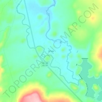
Name: El Tule topographic map, elevation, terrain.
Location: El Tule, Apache County, Arizona, Estados Unidos de América (34.35976 -109.41732 34.39976 -109.37732)
Average elevation: 1,837 m
Minimum elevation: 1,792 m
Maximum elevation: 1,959 m
Other topographic maps
Click on a map to view its topography, its elevation and its terrain.
Steamboat
Estados Unidos de América > Arizona > Apache County
Steamboat, Fort Defiance Agency / Tséhootsooí Bił Hahoodzo biyiʼdi, Apache County, Arizona, Estados Unidos de América
Average elevation: 1,969 m