
Make a donation
Gear up for your next adventure:
As an Amazon Associate, this site earns from qualifying purchases at no extra cost to you.
Gralheira topographic map
Click on the map to display elevation.
Make a donation
Gear up for your next adventure:
As an Amazon Associate, this site earns from qualifying purchases at no extra cost to you.
Gralheira
Gralheira foi uma freguesia portuguesa do município de Cinfães, distrito de Viseu, situada em plena serra de Montemuro, com 10,19 km² de área e 165 habitantes (2011). Densidade: 16,2 hab/km². A elevada altitude da sede de freguesia (1103 m) torna-a uma das mais altas aldeias de Portugal, a par de Pitões das Júnias na Distrito de Vila Real.
Make a donation
Gear up for your next adventure:
As an Amazon Associate, this site earns from qualifying purchases at no extra cost to you.
About this map
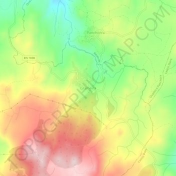
Name: Gralheira topographic map, elevation, terrain.
Average elevation: 1,145 m
Minimum elevation: 971 m
Maximum elevation: 1,318 m
Make a donation
Gear up for your next adventure:
As an Amazon Associate, this site earns from qualifying purchases at no extra cost to you.
Other topographic maps
Click on a map to view its topography, its elevation and its terrain.