
Make a donation
Gear up for your next adventure:
As an Amazon Associate, this site earns from qualifying purchases at no extra cost to you.
Pic de Troumouse topographic map
Click on the map to display elevation.
Make a donation
Gear up for your next adventure:
As an Amazon Associate, this site earns from qualifying purchases at no extra cost to you.
About this map
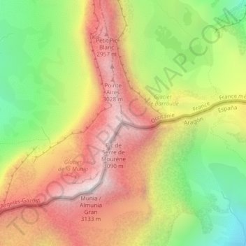
Name: Pic de Troumouse topographic map, elevation, terrain.
Average elevation: 2,522 m
Minimum elevation: 1,882 m
Maximum elevation: 3,115 m
Make a donation
Gear up for your next adventure:
As an Amazon Associate, this site earns from qualifying purchases at no extra cost to you.
Other topographic maps
Click on a map to view its topography, its elevation and its terrain.
Cirque de Gavarnie
Frankrijk > Occitanië > Hautes-Pyrénées > Gavarnie-Gèdre > Gavarnie
De cirque vormt het einde van de vallei van de "Gave de Gavernie". Gave is een veel voorkomende aanduiding voor een diep ingesneden rivier in de Pyreneeën. De cirque wordt omringd door verschillende toppen. Van oost naar west: le Petit Astazou, le Pic du Marboré, le pic Brulle, le pic de la Cascade,…
Average elevation: 2,364 m
Make a donation
Gear up for your next adventure:
As an Amazon Associate, this site earns from qualifying purchases at no extra cost to you.