Geolocate

Castroverde topographic map

Click on the map to display elevation.

About this map

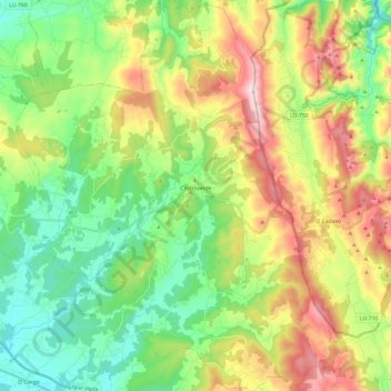
Name: Castroverde topographic map, elevation, terrain.

Location: Castroverde, Lugo, Galicia, Spain (42.93859 -7.43813 43.11439 -7.24337)

Average elevation: 633 m

Minimum elevation: 406 m

Maximum elevation: 1,026 m

Gear up for your next adventure:

🧢Hiking Hat - Sun-protective and breathable hats for long treks
Family Camping Tent - Spacious tent suitable for family camping trips
🥾Waterproof Trail Shoes - Shoes designed to handle wet terrain
🧴Sunscreen SPF - Broad-spectrum sunscreen for outdoor activities
🛶Waterproof Dry Bags - Keep electronics and clothes dry during river crossings

As an Amazon Associate, this site earns from qualifying purchases at no extra cost to you.