
La Garde topographic map
Interactive map
Click on the map to display elevation.
About this map
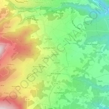
Name: La Garde topographic map, elevation, terrain.
Average elevation: 439 m
Minimum elevation: 213 m
Maximum elevation: 758 m
Other topographic maps
Click on a map to view its topography, its elevation and its terrain.
Chevalet
France > Auvergne-Rhône-Alpes > Loire > Roisey
Chevalet, Roisey, Saint-Étienne, Loire, Auvergne-Rhône-Alpes, France métropolitaine, 42520, France
Average elevation: 787 m
La Rivory
France > Auvergne-Rhône-Alpes > Loire > Roisey
La Rivory, Roisey, Saint-Étienne, Loire, Auvergne-Rhône-Alpes, France métropolitaine, 42520, France
Average elevation: 616 m