Geolocate

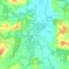
Corrabare topographic map

Click on the map to display elevation.

About this map

Name: Corrabare topographic map, elevation, terrain.

Location: Corrabare, Cessnock, New South Wales, Australia (-33.02212 151.15564 -32.87609 151.28413)

Average elevation: 223 m

Minimum elevation: 93 m

Maximum elevation: 519 m

Other topographic maps

Click on a map to view its topography, its elevation and its terrain.
Hunter Valley

Australia > New South Wales > Cessnock

Average elevation: 70 m

Mount Bright

Australia > New South Wales > Cessnock

Average elevation: 288 m

Gear up for your next adventure:

🥾Trekking Poles - Adjustable trekking poles to reduce knee stress and improve stability
🪑Insulated Seat Pad - Protect your seat from cold rocks and wet logs
🧥Softshell Jacket - Windproof and breathable jacket for hiking
🚲Handlebar Phone Mount - View topographic-map.com live while cycling
🦯Trekking Poles - Reduced impact on joints for steep topographic climbs

As an Amazon Associate, this site earns from qualifying purchases at no extra cost to you.