Geolocate

Varenna topographic map

Click on the map to display elevation.

About this map

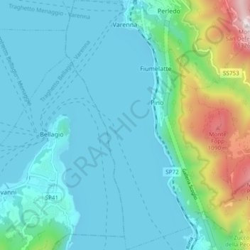
Name: Varenna topographic map, elevation, terrain.

Location: Varenna, Lecco, Lombardy, 23829, Italy (45.96322 9.26536 46.01500 9.31640)

Average elevation: 380 m

Minimum elevation: 191 m

Maximum elevation: 1,287 m

Other topographic maps

Click on a map to view its topography, its elevation and its terrain.

i Noc

Italy > Lombardy > Lecco > Dorio

Average elevation: 557 m

Gear up for your next adventure:

🧥Thermal Layer - Insulating layer for cold outdoor conditions
🔭Outdoor Binoculars - Lightweight binoculars for birdwatching and hiking
🧭GPS Handheld Device - Reliable GPS navigation for outdoor adventures
🧦Outdoor Socks - Durable socks designed for hiking and outdoor sports
🧰Emergency Multi-Tool - Compact multi-tool for outdoor survival

As an Amazon Associate, this site earns from qualifying purchases at no extra cost to you.