
Make a donation
Gear up for your next adventure:
As an Amazon Associate, this site earns from qualifying purchases at no extra cost to you.
Spanbeck topographic map
Click on the map to display elevation.
Make a donation
Gear up for your next adventure:
As an Amazon Associate, this site earns from qualifying purchases at no extra cost to you.
About this map
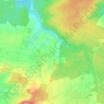
Name: Spanbeck topographic map, elevation, terrain.
Average elevation: 258 m
Minimum elevation: 200 m
Maximum elevation: 331 m
Make a donation
Gear up for your next adventure:
As an Amazon Associate, this site earns from qualifying purchases at no extra cost to you.
Other topographic maps
Click on a map to view its topography, its elevation and its terrain.
Lenglern
Deutschland > Niedersachsen > Landkreis Göttingen > Bovenden
Lenglern ist ein zum Flecken Bovenden in Niedersachsen gehörendes Dorf mit etwa 2200 Einwohnern. Es ist damit nach Bovenden der einwohnerstärkste Teilort des Fleckens, liegt im westlichen Teil des Leinegrabens und wird vom Leinetal durch den Höhenrücken der Lieth getrennt.
Average elevation: 178 m
Make a donation
Gear up for your next adventure:
As an Amazon Associate, this site earns from qualifying purchases at no extra cost to you.