Geolocate

Moisson topographic map

Click on the map to display elevation.

About this map
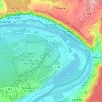
Name: Moisson topographic map, elevation, terrain.

Location: Moisson, Mantes-la-Jolie, Yvelines, Ile-de-France, Metropolitan France, 78840, France (49.05071 1.62006 49.08198 1.69781)

Average elevation: 59 m

Minimum elevation: 12 m

Maximum elevation: 179 m

Other topographic maps

Click on a map to view its topography, its elevation and its terrain.

Rodon

France > Ile-de-France > Yvelines

Average elevation: 167 m

Hautvilliers

France > Ile-de-France > Yvelines > Chevreuse

Average elevation: 127 m

La Corse

France > Ile-de-France > Yvelines > Élancourt

Average elevation: 165 m

Gear up for your next adventure:

🥾Waterproof Trail Shoes - Shoes designed to handle wet terrain
🧦Crew Hiking Socks - Comfortable socks for long-distance hikes
⛺Lightweight Backpacking Tent - Compact tent for efficient hiking trips
🧢Beanie Hat - Keep your head warm in cold weather
🧭GPS Tracker - Track your location in remote areas safely

As an Amazon Associate, this site earns from qualifying purchases at no extra cost to you.