
Eastern District topographic map
Interactive map
Click on the map to display elevation.
About this map
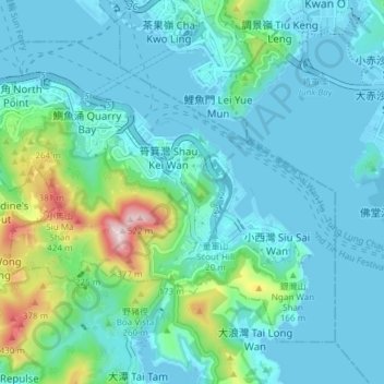
Name: Eastern District topographic map, elevation, terrain.
Location: Eastern District, Hong Kong Island, Hong Kong, China (22.24573 114.18633 22.30028 114.26160)
Average elevation: 84 m
Minimum elevation: -6 m
Maximum elevation: 513 m
Other topographic maps
Click on a map to view its topography, its elevation and its terrain.
19
China > Hong Kong > Hong Kong Island
19, Government Hill, Central, Central and Western District, Hong Kong Island, Hong Kong, China, Hong Kong Park
Average elevation: 143 m
Hong Kong Island
China > Hong Kong > Hong Kong Island
Hong Kong Island, Southern District, Hong Kong, 852, China
Average elevation: 36 m