Geolocate

San Carlos topographic map

Click on the map to display elevation.

About this map

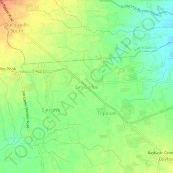
Name: San Carlos topographic map, elevation, terrain.

Location: San Carlos, Rosario, Batangas, Calabarzon, 4225, Philippines (13.82067 121.22263 13.86067 121.26263)

Average elevation: 128 m

Minimum elevation: 107 m

Maximum elevation: 152 m

Other topographic maps

Click on a map to view its topography, its elevation and its terrain.

Pinagsibaan

Philippines > Batangas > Rosario

Average elevation: 57 m

Gear up for your next adventure:

🥾Lightweight Hiking Boots - Boots for comfort and mobility on long hikes
Tent Footprint - Protect tent floor and increase durability
🧢Outdoor Cap - Protective cap for sun and rain during hikes
🗺️Topographic Maps - Detailed maps to explore trails, mountains, and wilderness areas
🛏️Sleeping Bag - Warm and compact sleeping bags for outdoor camping

As an Amazon Associate, this site earns from qualifying purchases at no extra cost to you.