Geolocate

Oottupara topographic map

Click on the map to display elevation.

About this map
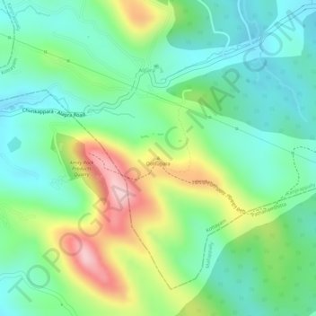
Name: Oottupara topographic map, elevation, terrain.

Location: Oottupara, Kanjirappally, Kottayam, Kerala, 686547, India (9.44800 76.76378 9.44810 76.76388)

Average elevation: 122 m

Minimum elevation: 35 m

Maximum elevation: 282 m

Other topographic maps

Click on a map to view its topography, its elevation and its terrain.
Nadukani

India > Kerala > Kanjirappally > Mundakkayam

Average elevation: 159 m

Chirakkadavu

India > Kerala > Kanjirappally

Average elevation: 63 m

Elivalikkara

India > Kerala > Kanjirappally > Mukkoottuthara

Average elevation: 167 m

Mundakayam

India > Kerala > Kanjirappally > Kannimala

Average elevation: 132 m

Kanjirappilly

India > Kerala > Kanjirappally

Average elevation: 228 m

Thalumkal

India > Kerala > Kanjirappally > Mundakkayam

Average elevation: 226 m

Koovappally

India > Kerala > Kanjirappally > Koovapally

Average elevation: 85 m

Mundakayam

India > Kerala > Kanjirappally > Punchavayal

Average elevation: 132 m

Gear up for your next adventure:

🥾All-Terrain Hiking Boots - Versatile boots for varied hiking conditions
🥾Trail Running Shoes - Lightweight and durable shoes for trail running
🌡️Emergency Mylar Blankets - Compact thermal protection for unexpected nights outdoors
🧦Merino Wool Socks - Moisture-wicking comfort for long-distance hiking
🥘Camping Cookware Set - Compact nesting pots and pans for trail cooking

As an Amazon Associate, this site earns from qualifying purchases at no extra cost to you.