Geolocate

Lingnan topographic map

Click on the map to display elevation.

About this map

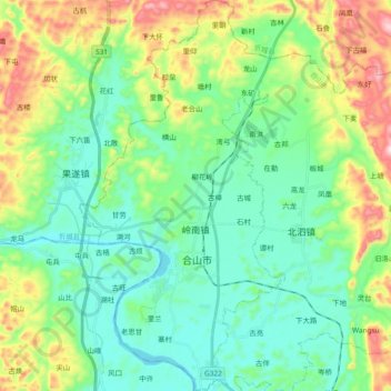
Name: Lingnan topographic map, elevation, terrain.

Location: Lingnan, Heshan City, Laibin, Guangxi, China (23.75656 108.82882 23.92845 108.92772)

Average elevation: 206 m

Minimum elevation: 72 m

Maximum elevation: 547 m

Gear up for your next adventure:

🥾Waterproof Trail Shoes - Shoes designed to handle wet terrain
🥾Approach Boots - Comfortable boots for hiking and climbing approaches
🪜Heavy Duty Carabiners - Multi-use clips for securing gear to your backpack
🛁Quick-Dry Microfiber Towel - Space-saving towel that dries rapidly on the move
💧Hydration Bladder - Hands-free hydration solution for long treks

As an Amazon Associate, this site earns from qualifying purchases at no extra cost to you.