Geolocate

Newbern topographic map

Click on the map to display elevation.

About this map

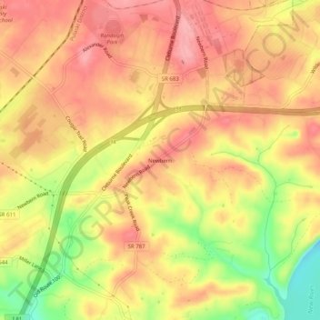
Name: Newbern topographic map, elevation, terrain.

Location: Newbern, Pulaski County, Virginia, 24126, United States (37.05346 -80.71062 37.09346 -80.67062)

Average elevation: 625 m

Minimum elevation: 553 m

Maximum elevation: 664 m

Other topographic maps

Click on a map to view its topography, its elevation and its terrain.

Pulaski

United States > Virginia > Pulaski County

Average elevation: 650 m

Hogan Lake

United States > Virginia > Pulaski County

Average elevation: 721 m

Parrott

United States > Virginia > Pulaski County

Average elevation: 604 m

Gear up for your next adventure:

🎒Hiking Daypack - Lightweight and durable backpacks for day trips and excursions
🥘Camping Cookware Set - Compact nesting pots and pans for trail cooking
🧢Hiking Hat - Sun-protective and breathable hats for long treks
🧭GPS Outdoor Watch - Smart watch for navigation and fitness tracking in nature
🦯Trekking Poles - Reduced impact on joints for steep topographic climbs

As an Amazon Associate, this site earns from qualifying purchases at no extra cost to you.