
Holystone topographic map
Interactive map
Click on the map to display elevation.
About this map
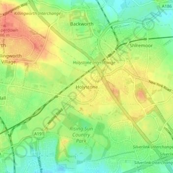
Name: Holystone topographic map, elevation, terrain.
Average elevation: 63 m
Minimum elevation: 42 m
Maximum elevation: 86 m
Other topographic maps
Click on a map to view its topography, its elevation and its terrain.
Willington Quay
United Kingdom > England > North Tyneside > Wallsend
Willington Quay, Howdon, Wallsend, North Tyneside, North of Tyne, England, NE28 6EA, United Kingdom
Average elevation: 23 m
Forest Hall
United Kingdom > England > North Tyneside
Forest Hall, North Tyneside, North of Tyne, England, NE12 7LH, United Kingdom
Average elevation: 61 m
North Shields
United Kingdom > England > North Tyneside
North Shields, North Tyneside, North of Tyne, England, NE29 6QF, United Kingdom
Average elevation: 25 m