
Брест topographic map
Interactive map
Click on the map to display elevation.
About this map
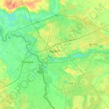
Name: Брест topographic map, elevation, terrain.
Location: Брест, Брестская область, Wit-Rusland (52.02378 23.56542 52.15245 23.85441)
Average elevation: 137 m
Minimum elevation: 123 m
Maximum elevation: 162 m
Other topographic maps
Click on a map to view its topography, its elevation and its terrain.
Барановичский район
Wit-Rusland > Брестская область
Барановичский район, Брестская область, Wit-Rusland
Average elevation: 183 m
Брестский район
Wit-Rusland > Брестская область
Брестский район, Брестская область, Wit-Rusland
Average elevation: 152 m
Жабинка
Wit-Rusland > Брестская область > Жабинка > Жабинка
Жабинка, Жабинковский район, Брестская область, 225101, Wit-Rusland
Average elevation: 141 m
Жабинковский район
Wit-Rusland > Брестская область
Жабинковский район, Брестская область, Wit-Rusland
Average elevation: 146 m