Geolocate

Kendel topographic map

Click on the map to display elevation.

About this map

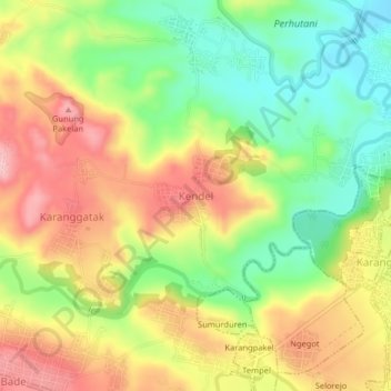
Name: Kendel topographic map, elevation, terrain.

Location: Kendel, Boyolali, Central Java, Java, 57385, Indonesia (-7.35551 110.70043 -7.31551 110.74043)

Average elevation: 181 m

Minimum elevation: 97 m

Maximum elevation: 268 m

Other topographic maps

Click on a map to view its topography, its elevation and its terrain.

Cluntang

Indonesia > Central Java > Boyolali

Average elevation: 1,033 m

Gear up for your next adventure:

🥘Camping Cookware Set - Compact nesting pots and pans for trail cooking
🔨Vehicle Emergency Tool - Safety tool for remote road trips to trailheads
🏃Hydration Running Vest - Carry water and maps close to your body for speed
🧢Outdoor Visor - Breathable visor for sunny hikes
💡LED Headlamp - Hands-free illumination for night hiking and camping

As an Amazon Associate, this site earns from qualifying purchases at no extra cost to you.