Geolocate

Eldridge topographic map

Click on the map to display elevation.

About this map

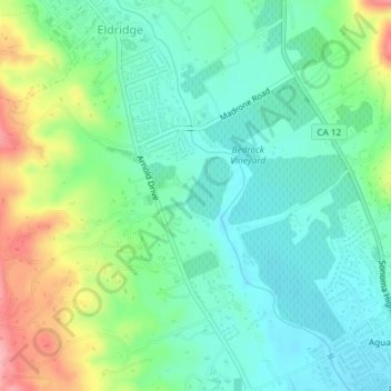
Name: Eldridge topographic map, elevation, terrain.

Location: Eldridge, Agua Caliente, Eldridge, Sonoma County, California, United States (38.32041 -122.51580 38.34934 -122.49453)

Average elevation: 76 m

Minimum elevation: 37 m

Maximum elevation: 163 m

Other topographic maps

Click on a map to view its topography, its elevation and its terrain.

Gear up for your next adventure:

🛌Down Sleeping Bag - Superior warmth-to-weight ratio for cold nights
Family Camping Tent - Spacious tent suitable for family camping trips
💡LED Camping Lantern - Illuminate your campsite with long-lasting lanterns
🛶Waterproof Dry Bags - Keep electronics and clothes dry during river crossings
🥾Trail Running Shoes - Lightweight and durable shoes for trail running

As an Amazon Associate, this site earns from qualifying purchases at no extra cost to you.