Geolocate

Castelsaraceno topographic map

Click on the map to display elevation.

About this map

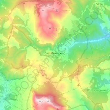
Name: Castelsaraceno topographic map, elevation, terrain.

Location: Castelsaraceno, Potenza, Basilicata, Italy (40.11321 15.91800 40.21061 16.03533)

Average elevation: 1,104 m

Minimum elevation: 607 m

Maximum elevation: 1,893 m

Other topographic maps

Click on a map to view its topography, its elevation and its terrain.

Viadotto Pantanelle

Italy > Basilicata > Potenza > Nemoli

Average elevation: 1,685 m

Gear up for your next adventure:

🛶Canoe Life Vest - Safety vest for water sports
🥾Waterproof Hiking Shoes - Durable shoes for wet and rugged trails
👟Trail Running Shoes - Agile footwear for fast-paced topographic exploration
🎒Hiking Backpack - Lightweight and ergonomic backpacks for day hikes or multi-day treks
🥾Hiking Shorts - Breathable shorts suitable for summer hikes

As an Amazon Associate, this site earns from qualifying purchases at no extra cost to you.