
El Portil topographic map
Click on the map to display elevation.
About this map
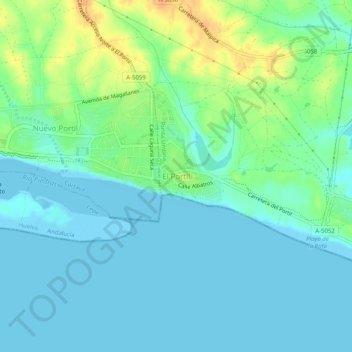
Name: El Portil topographic map, elevation, terrain.
Average elevation: 12 m
Minimum elevation: -1 m
Maximum elevation: 36 m
Other topographic maps
Click on a map to view its topography, its elevation and its terrain.
Ría de Punta Umbría
España > Andalucía > Comarca Metropolitana de Huelva > Punta Umbría
Average elevation: 3 m
Marismas del Odiel
España > Andalucía > Comarca Metropolitana de Huelva > Punta Umbría
Average elevation: 7 m