
Make a donation
Gear up for your next adventure:
As an Amazon Associate, this site earns from qualifying purchases at no extra cost to you.
Worthington Hills topographic map
Click on the map to display elevation.
Make a donation
Gear up for your next adventure:
As an Amazon Associate, this site earns from qualifying purchases at no extra cost to you.
About this map
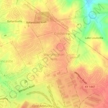
Name: Worthington Hills topographic map, elevation, terrain.
Location: Worthington Hills, Jefferson County, Kentucky, United States (38.30420 -85.53233 38.31509 -85.52202)
Average elevation: 221 m
Minimum elevation: 183 m
Maximum elevation: 238 m
Make a donation
Gear up for your next adventure:
As an Amazon Associate, this site earns from qualifying purchases at no extra cost to you.
Other topographic maps
Click on a map to view its topography, its elevation and its terrain.
Jefferson Memorial Forest
United States > Kentucky > Jefferson County > Louisville
Average elevation: 164 m
Louisville-Jefferson County (Balance)
United States > Kentucky > Jefferson County > Louisville
Average elevation: 157 m
Make a donation
Gear up for your next adventure:
As an Amazon Associate, this site earns from qualifying purchases at no extra cost to you.
Make a donation
Gear up for your next adventure:
As an Amazon Associate, this site earns from qualifying purchases at no extra cost to you.
Falls of the Ohio State Park
United States > Kentucky > Jefferson County > Louisville
Average elevation: 135 m
Bellewood
United States > Kentucky > Jefferson County > St. Matthews > Bellewood
Average elevation: 167 m