Geolocate

Indahag topographic map

Click on the map to display elevation.

About this map

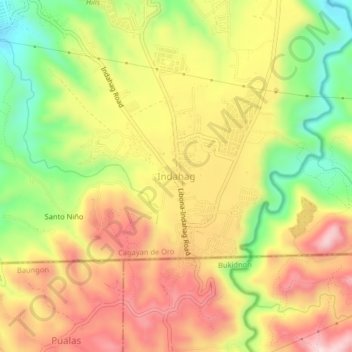
Name: Indahag topographic map, elevation, terrain.

Location: Indahag, Cagayan de Oro, Northern Mindanao, 9000, Philippines (8.40855 124.64592 8.44855 124.68592)

Average elevation: 217 m

Minimum elevation: 34 m

Maximum elevation: 377 m

Other topographic maps

Click on a map to view its topography, its elevation and its terrain.

Divisoria Plaza

Philippines > Cagayan de Oro

Average elevation: 11 m

Gaston Park

Philippines > Cagayan de Oro

Average elevation: 13 m

Rodelsa Circle

Philippines > Cagayan de Oro

Average elevation: 19 m

Iponan River

Philippines > Cagayan de Oro

Average elevation: 73 m

Xavier Heights

Philippines > Cagayan de Oro

Average elevation: 96 m

Calaanan Creek

Philippines > Cagayan de Oro

Average elevation: 70 m

Divisoria Plaza

Philippines > Cagayan de Oro

Average elevation: 11 m

Rodelsa Circle

Philippines > Cagayan de Oro

Average elevation: 19 m

Gear up for your next adventure:

🥾Mountain Trail Shoes - High-traction shoes for mountain trails
🧤Rechargeable Heated Gloves - Extreme warmth for Canadian winter expeditions
🥾Waterproof Hiking Boots - Essential footwear for rugged terrain and wet Canadian trails
🧴Insect Repellent - Protect yourself from bugs during outdoor adventures
Camping Groundsheet - Protect your tent from moisture and dirt

As an Amazon Associate, this site earns from qualifying purchases at no extra cost to you.