
Make a donation
Gear up for your next adventure:
As an Amazon Associate, this site earns from qualifying purchases at no extra cost to you.
Town of Roxbury topographic map
Click on the map to display elevation.
Make a donation
Gear up for your next adventure:
As an Amazon Associate, this site earns from qualifying purchases at no extra cost to you.
About this map
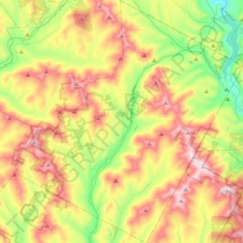
Name: Town of Roxbury topographic map, elevation, terrain.
Location: Town of Roxbury, Delaware County, New York, United States (42.20140 -74.68577 42.40399 -74.42828)
Average elevation: 641 m
Minimum elevation: 288 m
Maximum elevation: 1,087 m
Make a donation
Gear up for your next adventure:
As an Amazon Associate, this site earns from qualifying purchases at no extra cost to you.
Other topographic maps
Click on a map to view its topography, its elevation and its terrain.
Make a donation
Gear up for your next adventure:
As an Amazon Associate, this site earns from qualifying purchases at no extra cost to you.
Make a donation
Gear up for your next adventure:
As an Amazon Associate, this site earns from qualifying purchases at no extra cost to you.
Make a donation
Gear up for your next adventure:
As an Amazon Associate, this site earns from qualifying purchases at no extra cost to you.
South Kortright
United States > New York > Delaware County > Town of Stamford
Average elevation: 528 m
Harpersfield
United States > New York > Delaware County > Town of Harpersfield > Harpersfield
Average elevation: 594 m
Make a donation
Gear up for your next adventure:
As an Amazon Associate, this site earns from qualifying purchases at no extra cost to you.
East Masonville
United States > New York > Delaware County > Town of Masonville
Average elevation: 551 m
Make a donation
Gear up for your next adventure:
As an Amazon Associate, this site earns from qualifying purchases at no extra cost to you.
West Davenport
United States > New York > Delaware County > Town of Davenport
Average elevation: 453 m