
Thank you for supporting this site ❤️
Make a donation
Make a donation
Gear up for your next adventure:
As an Amazon Associate, this site earns from qualifying purchases at no extra cost to you.
Bismarck topographic map
Click on the map to display elevation.
Thank you for supporting this site ❤️
Make a donation
Make a donation
Gear up for your next adventure:
As an Amazon Associate, this site earns from qualifying purchases at no extra cost to you.
About this map
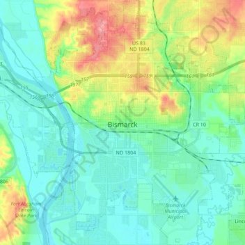
Name: Bismarck topographic map, elevation, terrain.
Location: Bismarck, Burleigh County, North Dakota, United States (46.75110 -100.84560 46.86705 -100.68851)
Average elevation: 523 m
Minimum elevation: 493 m
Maximum elevation: 605 m
Thank you for supporting this site ❤️
Make a donation
Make a donation
Gear up for your next adventure:
As an Amazon Associate, this site earns from qualifying purchases at no extra cost to you.
Other topographic maps
Click on a map to view its topography, its elevation and its terrain.
Bismarck Conservation and Outdoor Skills Area
United States > North Dakota > Burleigh County > Bismarck
Average elevation: 513 m