Geolocate

Abang topographic map

Click on the map to display elevation.

About this map

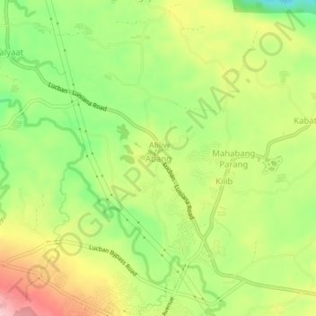
Name: Abang topographic map, elevation, terrain.

Location: Abang, Lucban, Quezon, Calabarzon, 4328, Philippines (14.11657 121.53514 14.15657 121.57514)

Average elevation: 416 m

Minimum elevation: 331 m

Maximum elevation: 511 m

Other topographic maps

Click on a map to view its topography, its elevation and its terrain.

Botocan River

Philippines > Quezon > Lucban > Kalyaat

Average elevation: 389 m

Camatian River

Philippines > Quezon > Lucban

Average elevation: 549 m

Gear up for your next adventure:

🧭GPS Outdoor Watch - Smart watch for navigation and fitness tracking in nature
🧢Hiking Hat - Sun-protective and breathable hats for long treks
🧢Sun Protection Cap - Breathable cap to protect from sun exposure
👟Leg Gaiters - Keep debris, mud, and snow out of your boots
Bushcraft Tarp - Versatile emergency shelter or gear protection

As an Amazon Associate, this site earns from qualifying purchases at no extra cost to you.