
Prokhorovsky District topographic map
Interactive map
Click on the map to display elevation.
About this map
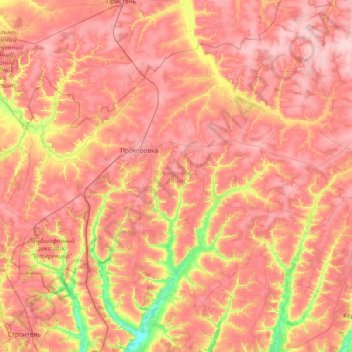
Name: Prokhorovsky District topographic map, elevation, terrain.
Average elevation: 217 m
Minimum elevation: 118 m
Maximum elevation: 277 m
Other topographic maps
Click on a map to view its topography, its elevation and its terrain.
Novikovo
Russia > Belgorod Oblast > Starooskolsky Urban District
Novikovo, Starooskolsky Urban District, Belgorod Oblast, Central Federal District, Russia
Average elevation: 140 m
Pyatnitskoye
Russia > Belgorod Oblast > городское поселение Пятницкое > Pyatnitskoye
Pyatnitskoye, городское поселение Пятницкое, Volokonovsky District, Belgorod Oblast, Central Federal District, 309665, Russia
Average elevation: 112 m