
Xambrê topographic map
Click on the map to display elevation.
Xambrê
Xambrê é um município brasileiro do estado do Paraná, localizando-se na Mesorregião do Noroeste Paranaense. Sua população, conforme estimativas do IBGE de 2018, era de 5 728 habitantes, estando numa altitude de 418 metros e numa área territorial de 363,25 km².
About this map
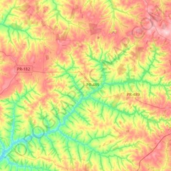
Name: Xambrê topographic map, elevation, terrain.
Average elevation: 366 m
Minimum elevation: 252 m
Maximum elevation: 499 m
Other topographic maps
Click on a map to view its topography, its elevation and its terrain.
Caramuru
Brasil > Paraná > Região Metropolitana de Umuarama > São Jorge do Patrocínio
Average elevation: 298 m
Reserva Biológica das Perobas
Brasil > Paraná > Região Metropolitana de Umuarama > Cianorte
Average elevation: 508 m
Serra dos Dourados
Brasil > Paraná > Região Metropolitana de Umuarama > Umuarama
Average elevation: 426 m