Geolocate

Meirol topographic map

Click on the map to display elevation.

About this map

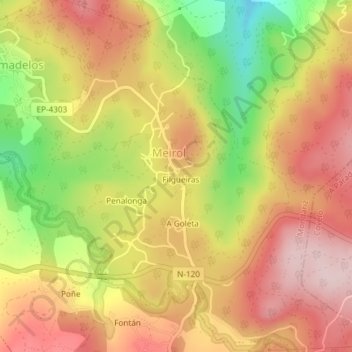
Name: Meirol topographic map, elevation, terrain.

Location: Meirol, Mondariz, Condado, Pontevedra, Galicia, España (42.19637 -8.43027 42.22378 -8.40059)

Average elevation: 288 m

Minimum elevation: 122 m

Maximum elevation: 406 m

Gear up for your next adventure:

🔪Outdoor Multitool - Versatile tool for repairs and food prep in the wild
🍽️Titanium Camping Spork - Ultralight and indestructible eating utensil
🧥Thermal Layer - Insulating layer for cold outdoor conditions
🧼Travel Hand Sanitizer - Keep hands clean when water is scarce
💡Portable Camping Lamp - Rechargeable lamp for campsite lighting

As an Amazon Associate, this site earns from qualifying purchases at no extra cost to you.