
Obura Wonenara District topographic map
Interactive map
Click on the map to display elevation.
About this map
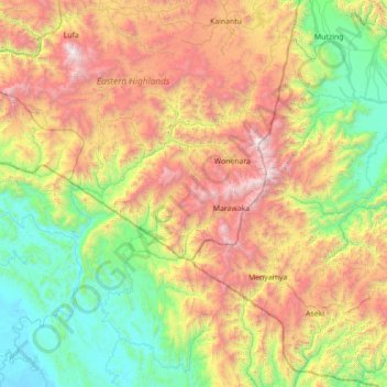
Name: Obura Wonenara District topographic map, elevation, terrain.
Average elevation: 1,175 m
Minimum elevation: 1 m
Maximum elevation: 3,617 m
Other topographic maps
Click on a map to view its topography, its elevation and its terrain.
Goroka
Papua New Guinea > Eastern Highlands > Goroka District
Goroka, Goroka District, Eastern Highlands, Highlands Region, Papua New Guinea
Average elevation: 1,890 m
Andakombe
Papua New Guinea > Eastern Highlands
Andakombe, Eastern Highlands, Highlands Region, Papua New Guinea
Average elevation: 1,153 m
Yonki Dam
Papua New Guinea > Eastern Highlands > Yonki
Yonki Dam, Yonki, Eastern Highlands, Highlands Region, Papua New Guinea
Average elevation: 1,297 m