Geolocate

Rusk County topographic map

Click on the map to display elevation.

About this map

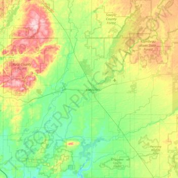
Name: Rusk County topographic map, elevation, terrain.

Location: Rusk County, Wisconsin, USA (45.29185 -91.54130 45.63902 -90.67855)

Average elevation: 379 m

Minimum elevation: 305 m

Maximum elevation: 548 m

Gear up for your next adventure:

🧣Evaporative Cooling Towel - Beat the heat during intense summer climbs
🥾Trekking Boots - Durable boots for long-distance trekking
🎒Backpack Rain Cover - External shield to keep your entire pack dry
🧦Merino Wool Socks - Moisture-wicking comfort for long-distance hiking
Family Camping Tent - Spacious tent suitable for family camping trips

As an Amazon Associate, this site earns from qualifying purchases at no extra cost to you.