Geolocate

Supe River topographic map

Click on the map to display elevation.

About this map

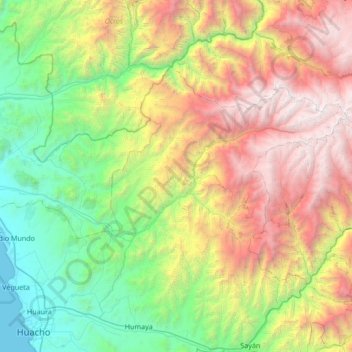
Name: Supe River topographic map, elevation, terrain.

Location: Supe River, Province of Huaura, Lima, Peru (-10.92674 -77.71196 -10.70127 -77.03597)

Average elevation: 1,832 m

Minimum elevation: 0 m

Maximum elevation: 5,162 m

Other topographic maps

Click on a map to view its topography, its elevation and its terrain.

Valdiviezo

Peru > Lima > Santa María

Average elevation: 77 m

Province of Huarochirí

Peru > Lima

Average elevation: 2,632 m

Rio Cañete

Peru > Lima > Huancachi

Average elevation: 4,031 m

Santa Bárbara

Peru > Lima > San Luis

Average elevation: 5 m

Gear up for your next adventure:

🧥Waterproof Jacket - Lightweight rain jackets for hiking and outdoor activities
🥾Trail Hiking Boots - Supportive boots for rough trails
🔋Lithium AA Batteries - Long-lasting power that performs in extreme cold
🌡️Emergency Mylar Blankets - Compact thermal protection for unexpected nights outdoors
🔭Compact Monocular - One-handed bird watching and trail spotting

As an Amazon Associate, this site earns from qualifying purchases at no extra cost to you.