Geolocate

A Franqueira topographic map

Click on the map to display elevation.

About this map

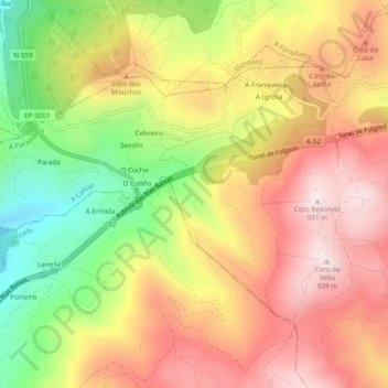
Name: A Franqueira topographic map, elevation, terrain.

Location: A Franqueira, A Cañiza, Paradanta, Pontevedra, Galicia, España (42.16074 -8.39591 42.18417 -8.34795)

Average elevation: 677 m

Minimum elevation: 355 m

Maximum elevation: 937 m

Other topographic maps

Click on a map to view its topography, its elevation and its terrain.

Montes da Paradanta

España > Galicia > Paradanta > A Cañiza

Average elevation: 614 m

Gear up for your next adventure:

🥾Waterproof Hiking Shoes - Durable shoes for wet and rugged trails
🧳Compression Sacks - Maximize space in your backpack by shrinking gear
🥾Mountaineering Boots - Supportive boots for climbing and high-altitude hiking
🧊Portable Cooler - Keep food and drinks cold during outdoor adventures
Lightweight Camping Tent - Portable shelter optimized for Canadian backcountry camping

As an Amazon Associate, this site earns from qualifying purchases at no extra cost to you.